

By EDUARDO CARRASCO VIDAL
Este artículo presenta un sistema autónomo basado en UAVs para la fiscalización pesquera. Se propone una arquitectura de control reactiva para la planificación centralizada de rutas y reconocimiento por medio de visión artificial. Los resultados indican una reducción significativa del tiempo de inspección, con una mejora del 70% en comparación con los métodos actuales. Este enfoque cuantitativo valida la efectividad de los drones, reduciendo la dependencia de decisiones basadas en intuición.
This article describes a UAV-based autonomous system for fishery control, in which a reactive control architecture is suggested for centralized flight planning and surface reconnaissance, using artificial vision. The result of this method shows a significant reduction in inspection time, with a 70% improvement compared to current procedures. This quantitative approach validates the effectiveness of drones, reducing reliance on gut-feeling decisions.
Fisheries surveillance/inspection is a critical task for the preservation of marine ecosystems and the sustainability of fishing industries. Traditionally, this surveillance has relied on the deployment of conventional human resources and assets, facing significant challenges in terms of geographic coverage and operational efficiency. Effective supervision of vast maritime areas is limited by logistical and financial constraints, often resulting in the inability to detect and prevent illicit activities such as illegal, unreported, and unregulated (IUU) fishing.
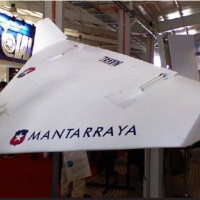
In view of this problem, rising technologies offer new possibilities. Unmanned Aerial Vehicles (UAVs) have a potentially transformational tool in the field of fishery control & surveillance. With the ability to cover large areas at low operational costs, UAVs constitute a promising solution to improve the efficiency and effectiveness of fishing-enforcement operations.
This article describes a different approach for fishery enforcement by incorporating a UAV-based autonomous system for fishery surveillance, in which a reactive control architecture allows a centralized flight-planning and an autonomous operation by the drones, making it a much more convenient method of enforcing fishery control in terms of range and response time. The system proposed is assessed via simulations and data analysis, the results of which validate the assumption that a UAV-based approach can significantly improve fishery surveillance/enforcement.
The problem
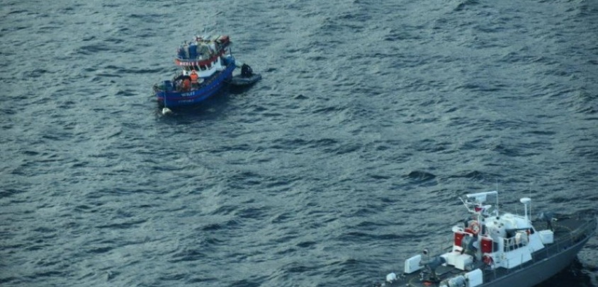
Currently, the inspection of a fishing vessel is carried out manually, for which RIB boats are deployed from a patrol ship and approach each fishing vessel to carry out the inspection, which takes time. But the problem occurs in fishing zones with multiple vessels; as time is limited, the patrol ship must decide which of them will be inspected, presenting a high degree of uncertainty in decision-making process.
Considering the foregoing, the problem can be basically stated as: “With the current resources, the process of fisheries control has a human element that decides which vessels to control based on partial and imperfect information”. In this context, it is proposed to develop a Multi-Agent System for a centralized route planning, which allows through a control center and drones (UAV), to carry out automatic search patterns to all surface vessels, in order to identify/select those that represent non-compliant conditions, potentially polluting or other specificities to be aware of, which can be done through Artificial Vision, and subsequently send a RIB to carry out the inspections.
Agents and their architectures
The use of autonomous crafts, both aerial and ground-based, has become a key strategy for an efficient monitoring over large areas. These crafts have found applications in multiple types of activities, showing their ability to reduce the need for human intervention in high-risk areas or of difficult access. In agriculture, autonomous vehicles are used to detect anomalies in crop growth and optimize harvests. In the military sector, they offer the possibility of carrying out offensive and defensive missions while minimizing risk to their personnel.
With regards to automation models, there are two main approaches: centralized and distributed. The centralized model is based on the existence of a top-level master agent that plans and assigns tasks to lower-level slave agents. These slave agents interact with passive elements of the system, such as fishing vessels. Although this centralized model is efficient in terms of the speed-of-instruction transmission, its reliance on a central processing unit means that any failure of the CPU can disrupt its operations.
The distributed approach on the other hand, consists of multiple agents working together. These multi-agents, not having the capacity or complete information to solve the problem on their own, must team-up to generate a plan and coordinate their actions. Although each agent in a distributed system is more complex, by having to make decisions collaboratively, this approach is considered more robust. The absence of a single focal point of failure significantly reduces the risk of the entire system failing.
Graph showing the Centralize and Distributed approach.
There are some common features in implementing these approaches which consists of: Sense, which involves collecting information from the place and circumstances in which the agent operates; Plan, which determines the tasks to be carried out to meet an objective; and Act, which consists of carrying out the planned actions. In this context, it is possible to discern the differences between the paradigms that mainly affect the planning phase on how sensory information is processed and the needs to generate an environment based on recognition maps or vision of the real-world with the available information.
In the field of artificial intelligence (AI) applied to autonomous systems, there are three main paradigms: deliberative, hybrid and reactive.
The deliberative approach requires a complete and detailed depiction of the environment in which is operating. These systems, which implement grid-based autonomous navigation and advanced planning, can predict behaviors, making complex decisions. A good example would be a drone system designed to protect a task force, where each drone performs a surveillance of the surroundings before acting. However, this model faces limitations in its speed of response due to the need to process large amounts of information and display it.
On the other hand, the hybrid approach combines reactive and deliberative elements, striking a balance between response to immediate stimulus and planning based on detailed models of the environment. This architecture is particularly useful in operating areas where reception of signals such as GPS is limited or non-existent. However, its implementation may be excessive for applications in open surroundings.
Finally, the reactive approach stands out for its rapid-response ability and adaptability in dynamic surroundings. In the military field, it can be seen in the use of unmanned surface vehicles (USV), land robots equipped with LiDAR for explosives detection, among others. This model does not require a detailed representation of the world but focuses on responding efficiently to specific environmental stimulus.
The reactive architecture is notable for its ability to fast-response by subdividing conduct into hierarchical layers with survival tasks at lower levels and more complex functions at higher levels, making it ideal for dynamic environments with moving targets. Although it may have shortcomings in complex problem-solving or detailed mapping, its main advantage lies in the ability/agility to interact in real-time, as is the case with fishing vessels on the move.
Design of a Centralized Multi-Agent System
A centralized 3-tier approach was selected for the design of the system. In the proposed architecture for the UAV monitoring system, the three hierarchical levels are as follows: the master agent, the slave agents, and the passive agents. The master agent, at the top level, detects vessels within its radar range and generates efficient routing tracks. It uses the closest-first algorithm to optimize the routes and assigns them to the slave agents for execution.
At the second level, slave agents share uniform features and capabilities, adding an element of redundancy to the system. They are equipped with a reactive architecture, especially suitable for fast-response dynamic systems, not requiring a detailed model of the world to operate.
At the last level, passive agents, are the elements of the system that do not actively participate in decision-making.
This centralized hierarchical structure offers multiple advantages. It provides fast response times for issuing commands and facilitates the optimization of control algorithms, since they only need to be updated in the central processing unit.
The following graphic represents the sense-control-act cycle that takes place in the system's slave agents, showing how they dynamically interact with the environment. This cycle starts at the sensing layer, where the slave agents collect information about their immediate or local environment.
In the control layer, the collected information is processed, evaluating the current conditions, and making decisions based on a set of predefined rules. Priority is given to survival actions, ensuring the safety and integrity of the agent. For example, if a drone experiences an unexpected alteration in its trajectory during flight, such as an abrupt change in tilt, it activates flight stabilization protocols.
Once a decision has been made, the act layer executes the respective action, allowing it to respond adaptably to a variety of situations without interrupting its main functions. For example, in the event of a deviation in its trajectory, the agent adjusts its power setting to stabilize the flight while at the same time maintaining its course to the target. This method ensures that functional tasks, such as tracking a predetermined route to a point of interest, remain on course despite interruptions.
The sense-control-act cycle is key for the autonomous and efficient operation of slave agents, providing immediate response to changing environmental conditions, thus ensuring both agent survivability and mission-accomplishment.
Model simulation implementation
The implementation of the design is based on a master agent installed in a control tower onboard a patrol vessel, integrated to one of the ship's navigation radars. As a result, this system will detect fishing vessels, determine their distance, and share this information to the central processing unit.
To test the viability, analyze the possibilities of the system and study the performance under different conditions, Agent-Based Simulation Systems has been used.
In each step of the simulation, the master agent identifies the location of the fishing vessels and generates specific tracks for each slave agent. These slave agents are directed towards the passive agents, and through a recognition system, evaluate the probability that they unveil aspects of interest for inspection. The routes are continuously adjusted according to the movement of the targets-of-interest, allowing drones to be reassigned to inspect closer vessels if their proximity-rate changes.
The following figure shows the simulation system in a Netlogo software, displaying five drones with specific operational restrictions in range and battery performance, symbolized by percentages of residual autonomy. The drones leave a trail marking the route flown and the surface vessels being identified with an assigned degree of criticality. In addition, a dotted circle line around the control tower displays the maximum radar range, defining the operational area. Ships beyond this limit are outside the drone´s response capability.
The next figure illustrates a simulation in a Webots software, focused on the stabilization of a drone. The model shows a 6° degree of freedom in maneuvering and balancing on its axes. The simulation includes programming layers that process images to evaluate the surface vessels detected. This image-analysis helps determine whether a fishing vessel should be inspected, based on predefined criteria that identify potential threats.
Experiments and results
Under the experimentation scenario of this work, the output metric used is the Average Time of Inspection (ATI), which corresponds to the average time in which a slave agent (drone) performs an inspection over a passive agent (fishing vessel).
ATI = total flight time/total number of identified vessels.
This metric is influenced by the following variables: number of vessels, number of drones and probability of failure (in the drones), allowing to analyze how these parameters and their variations impact the output metric value (ATI).
Results of the drone model
With the results of the experiments and the consequent database on hand, an analysis of variance (ANOVA) is used to determine which factors or combinations of factors are most relevant and how they affect the output variable.
After analyzing these results, the average inspection time of a drone model is 75.58 seconds, i.e., on average, a drone takes 1.26 minutes to inspect a fishing vessel within a radius limited to the unit´s radar range.
The following graph shows the effects generated on the mean of this metric by each factor and defined levels. It displays how different variables affect the ATI. We can see that as the number of surface vessels increases, the ATI decreases, indicating higher efficiency. The probability of drone failure shows a slight increase in ATI, suggesting that failures do not have a significant impact on inspection time. The dotted red line represents the overall average ATI effect across all test scenarios.
The next graph shows how ATI is influenced by the interaction of variables. Each graph in the matrix shows how ATI changes when two variables interact with each other, keeping the third constant.
For example, in the top left graph, we can see that as the number of vessels increases, the ATI decreases, but this effect is altered when the number of drones is changed. In the middle graph in the bottom row, the probability of failure appears to have an increasing impact on the ATI as the number of drones increases.
Comparison with the current situation
The model has only one-single input parameter, which is the number of boats to be inspected, and the output metric is the same as the one defined to evaluate the proposal, that is, the ATI.
Once the experiment of this manual/actual model is performed, it is determined that the overall effect on the ATI is 254.39 seconds (4.24 minutes).
Considering that the overall effect obtained with this proposal was 75.58 seconds, the drone model shows a significant improvement in the output metric, decreasing the inspection time.
With these results, it can be noted that the model represents a variation rate of 70%, verified by a statistical test (paired t-test), attesting that the model's performance has improved.
This graph compares the efficiency of inspections using boats and drones through histograms and Q-Q plots. The histograms show a higher efficiency of drones, showing a more concentrated and reduced time-distribution. Both Q-Q plots, with R² values close to 1, suggest normal dispositions, statistically supporting the improved efficiency employing drones.
Conclusions
Using this model, the hypothesis tested was confirmed, since a decrease of 178.81 seconds, equivalent to 70.28%, was achieved when comparing the implementation of the proposed drone system and a simulation of the current method using a patrol ship/inspection boat.
This study goes beyond the intuitive perception of the advantages of using drones, specifically quantifying the timesaving compared to traditional methods. This quantitative approach validates the effectiveness of drones in maritime surveillance/inspections and reduces reliance on gut-decisions.
Los avances tecnológicos han remodelado el panorama de la guerra moderna, siendo los drones un catalizador fundamental e...

Desde una perspectiva histórica, las “máquinas inteligentes” nacieron en el ámbito de la defensa para tomar decisiones o...
¿Los océanos serán transparentes? Algunos reportes1 relacionados con el análisis sobre la renovación de la flota de...

“El crimen organizado se combate como región o no se combate (Tohá, 2024)1" Miles de millones de personas utilizan...
Los recientes sucesos ocurridos con motivo del conflicto bélico en Rusia y Ucrania, nuevamente han puesto en primer plan...

Versión PDF
Año CXXXX, Volumen 143, Número 1009
Noviembre - Diciembre 2025


ÚLTIMA EDICIÓN
Noviembre - Diciembre 2025
e-ISSN: 0719-4129
ISSN: 0034-8511
Avda. Jorge Montt N° 2400, Las Salinas,
Viña del Mar.
Teléfono: +56 322 848 905
Casilla 220 Correo Central Valparaíso.
Revista indexada en Latindex 2.0
© 2026 Revista de Marina. Todos los derechos reservados.


Inicie sesión con su cuenta de suscriptor para comentar.-