
By MATÍAS SIFÓN ANDALAFT
Los océanos son parte fundamental de la vida del planeta Tierra, por lo tanto, su monitoreo es esencial. La tecnología de cables submarinos SMART (Science Monitoring and Reliable Telecommunications) busca formar una red mundial de vigilancia compuesta por sensores en cables submarinos de telecomunicaciones para un mejor conocimiento del océano, el cambio climático, la seguridad de los cables submarinos y la detección y vigilancia de terremotos y tsunamis. Actualmente no existe ninguna red mundial de vigilancia de esta envergadura, debido a los excesivos costos que implica mantenerlos.
Summary: The ocean is a fundamental part of life on Earth and therefore observation of it is essential. SMART Cables seeks to form a global observing network consisting of sensors on subsea telecommunications cables for a better understanding of the ocean, climate change, cable security and support in the detection and monitoring of earthquakes and tsunamis. Currently there is no global monitoring network of this scale and scope, due to the excessive cost of maintaining the systems in operation.
The ocean covers about 70% of our planet. It is responsible for approximately 50% of the oxygen we breathe, and it makes all life on our planet possible. It is also responsible for making it look blue when observed from space. The ocean plays a fundamental role in regulating the climate. It produces most of the water vapor, which condenses and creates clouds, and then releases it as rain. It stores 90% of the heat generated by greenhouse global warming and 25% of the carbon dioxide produced by fossil fuel burning.
Better knowing and understanding the ocean is essential to manage various threats that society faces, associated with natural and anthropic origin phenomena; climate change, global warming, ocean circulation, sea level rise, tsunamis, earthquakes and others. However, given the extent of the ocean, it is difficult and expensive to explore and observe on a sustained basis. According to the 2023 report of the Seabed 2030 program of the General Bathymetric Chart of the Oceans (GEBCO), only 24.9% of the ocean floor is known with good resolution. Due to the lack of data and the complexity of the models that represent the phenomena that occur in the ocean, the atmosphere, and the interaction between both, it is difficult to understand and predict them, not being enough to effectively evaluate the threats that society faces due to these phenomena. An alternative that has been proposed as part of the solution, related to the acquisition of data from the seafloor, is the integration of sensors that measure various ocean variables using the infrastructure of submarine telecommunications cables. This initiative is called SMART Cables (Scientific Monitoring And Reliable Telecommunications).
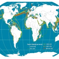
Today, submarine cables are the main structure supporting data transmission in the world. Commercial internet is based on them. Figure 1 shows the current distribution of submarine cables globally. Some interesting aspects that can be seen in the figure are the large number of existing cables and that their routes are concentrated in some oceans, with many more cables in the northern hemisphere than the southern hemisphere, leaving a significant area without (cable) coverage in the South Pacific. To mitigate this, the Humboldt transoceanic cable will connect Sydney, Australia with Valparaíso, Chile.
SMART Cables promotes using to-be-deployed commercial submarine cable infrastructure (such as Humboldt) to populate the ocean floor with sensors with minimal impact on both the environment and the telecommunications industry. A primary requirement is that there is no interference between the telecom and sensing portions of the combined system. Integrating the submarine cable industry with science and society is an optimal solution.
The SMART Cables concept is based on the deployment of oceanographic sensors in underwater telecommunications cable installations, as a promising solution to obtain information from large areas in real time, as a critical factor to understand and manage urgent environmental problems, such as climate change and early warning and management of seismic and tsunami threats. By using the infrastructure of submarine cables, it is possible to monitor hard-to-reach places very efficiently. Considering that there are already dedicated submarine cables for scientific research and early warning, their integration with telecommunications cables should not be complex. The ideal result would be that, in the cables represented by lines in Figure 1, there were SMART repeaters every 70 km or so, which would allow a practical and affordable global ocean floor-based monitoring network.
The Global Ocean Observing System (GOOS) has defined the Essential Ocean Variables (EOV’s) to effectively provide oceanographic forecasts and early warning, climatological projections and assessments, and to protect ocean health and its benefits. Among these variables are ocean temperature and pressure, with SMART Cables being the potentially most extensive and cost-effective system to achieve such measurements (Howe et al. 2022).
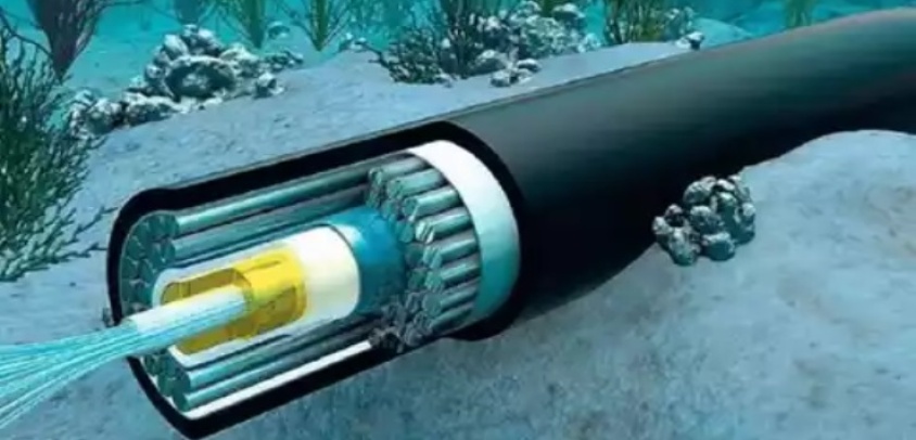
SMART repeaters can theoretically have as many sensors as decided, however, temperature and pressure sensors have been chosen, in conjunction with accelerometers (a possible configuration of SMART repeaters and their sensors is shown in figure 2). It must be considered that, due to the nature of the parameters to be measured, both the pressure and temperature sensors must be in contact with the environment, while the accelerometer can be inside the casing. In this model, the data generated by the sensors is transmitted through the same telecommunications network and uses its infrastructure for electrical power. As mentioned above, installation and maintenance efforts must be matched with those of the cables, but there are also other factors to consider in terms of the benefits of this concept, in addition to the richness of the data that will be obtained. Since the sensors are on the seabed, the possibility of vandalism of the instruments is drastically reduced, mitigating one of the problems that maintainers of other observing systems such as buoys or land stations must deal with, as well as intermittencies in transmissions, due to power supply problems or the transmission method itself (satellite, cellular network, etc.).
The ocean is currently being monitored mainly with in-situ vessels, buoys, anchoring systems, or floats, and through remote sensors, such as the various existing satellite techniques. Even so, the ocean floor remains poorly observed and monitored, so a complementary strategy is required to measure on the ocean floor (i.e. the ocean bottom boundary condition). A justification of the above is that deep Antarctic waters are warming due to the constant absorption of heat, contributing to sea level rise. Additionally, the circulation of the southern Atlantic is changing, which is associated with variations in ocean temperature, heat flow at the ocean-atmosphere interface and sea level, suggesting that the deep circulation is a relevant element in the global climate. Thus, the temperature sensors on SMART cables would provide data with greater spatial and temporal resolution in the deep ocean than current techniques allow.
Global warming has caused, on average, sea level rise to occur at rates of 3.0 +/- 0.4 mm/year since 1992, with an estimated acceleration of 0.084 +/- 0.025 mm/year2, which implies that, if these values were maintained, sea level would have risen 65 cm by the year 2100 (Howe et al. 2022), however this change is not homogeneous due mainly to the effects of mass changes resulting from ice melting, expansion of water due to warming causing changes in ocean volume, changes in terrain heights, etc., which is why different measurement techniques and sensors are required to promote to the study of the particular contributions in each place. In this sense, both pressure and temperature play essential roles.
Waves generated by the wind, with periods of less than 30 seconds, play a crucial role in the exchange of heat and gases between the ocean and the atmosphere and can be a threat in coastal areas. Due to their wavelength, which in deep waters are always much smaller than the depth, they cannot be measured from the seabed at more than 1000 meters depth, which is why satellites and floating buoys are used. However, the need to observe these waves near the coast and in real time increases day by day, so SMART sensors on the continental shelf and areas near the coast constitute a valuable alternative that could provide information on the amplitude, period and even direction (Howe et al., 2019) of these waves.
Another relevant aspect is tsunami monitoring, which is done by measuring pressure variations from the seabed mainly through DART (Deep-ocean Assessment and Reporting of Tsunami) technology developed by the National Oceanic and Atmospheric Agency of the United States (NOAA). DART measurements are near real time, but spatially very sparse, with high maintenance costs. The transmission of information is conducted through satellite systems through a buoy connected acoustically with the sensor on the seabed that has electrical power systems using batteries, which require frequent renewal. To avoid unnecessary battery consumption, there are only few transmissions per day, but they increase the frequency if they detect an earthquake or tsunami. The DART system is one of the best alternatives for monitoring tsunamis in real time in the deep ocean, providing data for tsunami propagation model predictions for both early warning and scientific research.
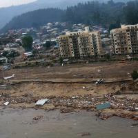
The importance of monitoring these phenomena in open waters is that, given their geophysical characteristics, this kind of waves can cross the ocean and affect coasts that are thousands of kilometers from their place of origin, potentially causing great damage. Timely alerting of coastal communities is crucial. It is essential to discriminate whether a tsunami will affect the community of interest sufficiently to perform an evacuation, since an unnecessary evacuation will lead into excessive costs for the system (economic, credibility, community effort, possible accidents during the evacuation process, etc.). That said, a valuable tool used today for tsunamis generated by subduction megathrust earthquakes (e.g. Maule 2010, Tohoku-Oki 2011, Valdivia 1960, etc.) is computational modeling. These allow a good estimate of the possible impact of this type of tsunami, which can take several hours to reach distant coasts. Good monitoring with direct observation of the propagation of a tsunami in deep waters allows not only to corroborate that the computational model is correct (or not), but also to observe the behavior of tsunamis generated by sources other than subduction megathrust earthquakes, as was the case of the tsunami generated by the eruption of the Hunga-Tonga Hunga-Ha’apai volcano in January 2022. For these types of events, there are presently no operational computational models that allow estimating the tsunami threat to carry out a timely evacuation, mainly due to the complexity of the tsunami generation mechanism (see figure 3), which for this case and many others can’t be determined in useful times for early warning, so monitoring the propagation of the tsunami is essential to alert coastal communities. Although DART buoys are an excellent tool, since they are installed somewhat close to the coasts with subduction zone and other earthquake fault regions, they are not enough, maintaining blind areas, such as in the South Pacific Ocean (see figure 4).
In the case of seismicity, like the other variables, there are also blind spots to cover; The cost of installing underwater seismological instruments is extremely high, so most of the instruments are on land, which complicates the analysis. Presently the only operational real time seafloor seismic instruments are in dedicated science and early warning cable arrays in the Pacific off Japan and the US/Canada west coasts. If there were accelerometers widely distributed in submarine cables, the study of seismicity would be greatly enhanced both scientifically and for early warning, as well as for engineering studies and others (e.g., building codes).
An alternative to mitigate the above observing gaps for tsunami, sea surface elevation and related seismicity would be the implementation of SMART Cables, although for the area of interest in the South Pacific there are currently no submarine cables that crosses the ocean basin. However, the previously mentioned Humboldt telecommunications project that aims to link Australia, New Zealand and Chile using subsea fiber optic cables will not only cover that blind space, but will also cross 4 major tectonic plates, boosting the study of seismicity, being a direct contribution to earthquake and tsunami early warning and scientific research.
Although it is possible to obtain multiple benefits from SMART technology, the Joint Task Force (JTF) has decided to use it mainly to address two issues; (1) the permanent acquisition of data that makes it possible to evaluate the phenomena associated with climate change (e.g., ocean circulation, heat content and sea level rise) and (2) contribute to the sea level monitoring network to enhance tsunami early warning systems, both through ocean bottom pressure and acceleration sensors. JTF SMART Cables is an initiative led by 3 United Nations agencies: the International Telecommunication Union (ITU), the World Meteorological Organization (WMO) and the Intergovernmental Oceanographic Commission (IOC/UNESCO).
Currently, there are different projects being considered with SMART cables. The most notable ones link New Caledonia with Vanuatu and the other in Portugal, which will connect Lisbon, Madeira and the Azores in a ring. These two projects have fundings for the implementation of this technology and are expected to be the first to come into operation in 2026. The first of them will have an extension of about 300 kilometers, with between 2 and 4 SMART sensor modules, while the second will be of 3,700 kilometers, with 30-50 SMART modules. Other projects that are expected to include SMART capability in the future are the already mentioned Humboldt project, as well as the one that will connect New Zealand to Antarctica, Chile-Antarctica, Medusa linking Lisbon to Egypt via Barcelona, Marseilles, Sicily and Crete, Norway to Japan (two systems).
The implementation of SMART technology could improve our understanding of geophysical processes that occur on Earth such as ocean temperature, ocean circulation, sea level rise, tides, currents, tsunami, and earthquakes, through observations on the seafloor. All are related to climate change.
SMART Cables combines two key concepts; the increase demand to achieve greater global connectivity and the urgent need to coherently address climate change and ocean management. Achieving this constructive collaboration will directly advance the Blue Economy and Ocean Discovery, as well as the United Nations Sustainable Development Goals. The telecommunications industry will continue with the installation of submarine cables far into the future - we must take advantage of this global, sustained infrastructure to do science for the direct benefit of the planet and humanity.
Bibliografía
Las líneas de comunicaciones marítimas constituyen uno de los cuatro objetivos de la estrategia naval, siendo esenciales...
La palabra terremoto tiene su origen en el latín terraemotus, cuyo significado es “movimiento de la tierra”. Según el di...
La noche del 27 de febrero del 2010, Chile se vio afectado por un terremoto grado 8,8 en la escala sismológica de magnit...
Versión PDF
Año CXXXX, Volumen 143, Número 1009
Noviembre - Diciembre 2025


ÚLTIMA EDICIÓN
Noviembre - Diciembre 2025
e-ISSN: 0719-4129
ISSN: 0034-8511
Avda. Jorge Montt N° 2400, Las Salinas,
Viña del Mar.
Teléfono: +56 322 848 905
Casilla 220 Correo Central Valparaíso.
Revista indexada en Latindex 2.0
© 2026 Revista de Marina. Todos los derechos reservados.


Inicie sesión con su cuenta de suscriptor para comentar.-